
As another El Niño develops across the Pacific, photographs from earlier droughts offer a reminder of what prolonged dry weather can mean on small islands. Water shortages are not simply numbers on a rainfall chart. They can mean hours spent waiting for drinking water, families carrying a day’s supply home, reservoirs reduced to shallow pools, vegetation drying out, and even normally wet ground becoming dry enough to burn.
These photographs from the Marshall Islands, Pohnpei and Yap document those impacts across more than 25 years.
A warning preserved in photographs
Majuro’s water lines. Families waiting on Ebeye. Residents carrying a day’s water home from Kwajalein. Wetlands burning on Pohnpei. An almost-empty reservoir in Yap.
The photographs were taken years apart, and drought does not affect every island in the same way. But together they show why El Niño is watched so closely across Micronesia. On islands where drinking water, crops and ecosystems depend heavily on rainfall, a shift in Pacific weather patterns can quickly become part of everyday life.
As the Pacific enters another El Niño period, these images are not evidence of what will happen on any particular island. They are a record of what has happened before—and of why communities across the region prepare when the rains begin to disappear.
Majuro, March 13, 1998: The lines for water grow longer
In March 1998, The Marshall Islands Journal photographed residents lined up at three Japanese government-provided water machines in Majuro. Its original caption was simple: “Lines at the three Japanese government-provided water machines grow longer each day.”
The photograph was taken during one of the most severe El Niño droughts in recent Pacific history. With very little rain replenishing Majuro’s reservoir and household catchments, normal water supplies became increasingly scarce. The picture captures the human side of the emergency: containers gathered around the machines and people waiting for something normally taken for granted.
The photograph appeared in the Journal’s March 13, 1998 coverage.


Photo/source: Marshall Islands Journal (Note: photo enhancement could not extract the entire photo caption.)
View “El Niño hits Majuro hard”
Ebeye, April 3, 1998: Families wait for water
A few weeks later, FEMA photographer Angel Santiago documented the drought on Ebeye.
One photograph shows families gathered with buckets and other containers as they wait for water distribution. On an island as densely populated as Ebeye, prolonged drought creates a particular problem: there is little land available for freshwater storage, and the community depends heavily on rainfall and outside infrastructure.
The FEMA photograph, taken April 3, 1998, is now preserved in the public domain.


Photo: Angel Santiago/FEMA
View the original FEMA 917 photograph
Ebeye and Kwajalein, April 3, 1998: Bringing home a day’s water
Another Santiago photograph from the same day shows residents returning to Ebeye after obtaining water from the U.S. military installation on Kwajalein.
According to FEMA’s archival description, they were carrying a day’s supply of water.
The photograph illustrates something rainfall statistics alone cannot: during a severe drought, finding enough water for ordinary daily life can become an activity around which families must organize their day.


Photo: Angel Santiago/FEMA
View the original FEMA 918 photograph
Several additional FEMA photographs from the 1998 emergency survive in the Ebeye archive. Together, they provide a rare photographic record of how the drought affected daily life in the Marshall Islands.
Browse the FEMA photographs from Ebeye
Pohnpei, 1998: Even wet ground burned
The same El Niño looked different on Pohnpei.
Pohnpei is one of the wettest islands in Micronesia, but photographs preserved by the College of Micronesia-FSM show an extraordinarily dry landscape during the 1998 drought.
Grasslands took on what the photographer described as a savannah-like appearance. Vegetation dried and fires burned across the island. Photographs from February document the Pwisehn Malek burn area, while another series records a fire near the hospital on March 14.
Perhaps the most striking observation accompanies a photograph of burned land that would ordinarily have been wet. The photographer explains that the area was normally a swamp and taro patch. During the drought, it became dry enough to burn.
The collection provides an unusual first-hand visual record of El Niño on Pohnpei—not only water scarcity, but a profound change in a normally wet tropical landscape.


Photos/source: College of Micronesia-FSM
Explore the Pohnpei 1998 drought photographs
Yap, 2024: The reservoir nearly disappears
More than a quarter-century later, another drought produced strikingly similar scenes in Yap.
ABC Pacific journalist Carl Smith photographed Yap’s main reservoir in 2024 after months of extremely dry weather. One photograph shows Mayor Jeff Adalbai looking across the depleted reservoir. Another gives a wider view of the exposed reservoir bed and the relatively small amount of water remaining.
ABC reported that the reservoir had fallen to roughly 15 percent capacity after about three months without rain.
Unlike the 1998 photographs, these images are recent enough that many people across Micronesia will remember the drought. They provide a bridge between the historic 1997–98 El Niño and the continuing vulnerability of island water supplies today.

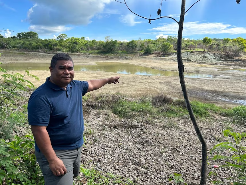
Photos: Carl Smith/ABC Pacific
View ABC Pacific’s Yap drought photo story
ABC also published the reservoir photograph in a separate presentation:
The Pulitzer Center’s publication of the project also reproduces the photographs and provides additional context about efforts to make Yap’s water supply more resilient.



Be the first to comment on "When the Rain Stopped: Images of Drought in Micronesia"